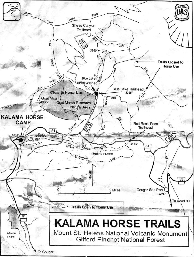
"Kalama Horse Camp"
Mount St. Helens National Monument
Gifford Pinchot National Forest
If you have corrections for the maps, email us
"This Trail System Map is being worked on..."
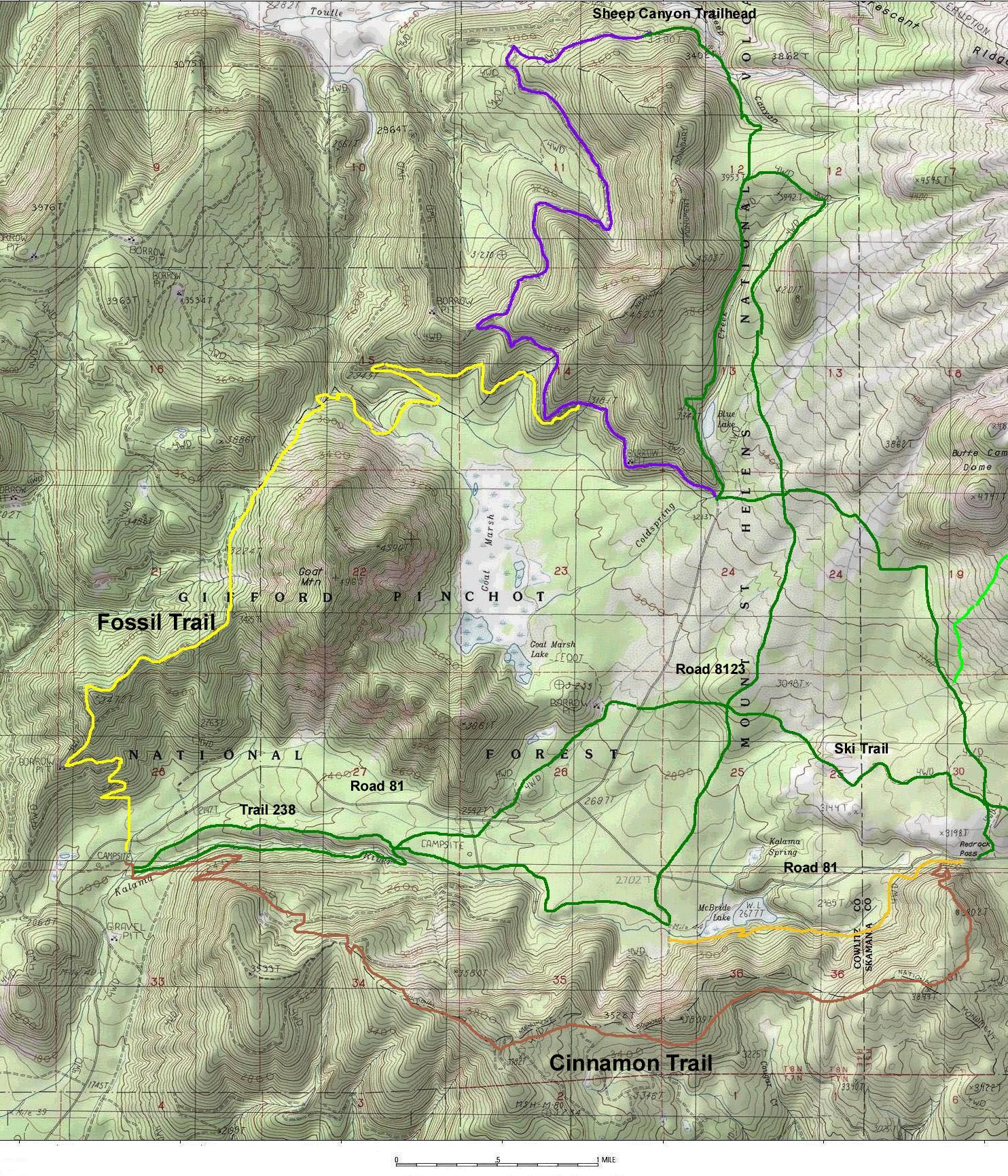
"New Fossil Trail"
Fossil Trail No. 242 doesn't offer views of the peak, but it does lead through a couple
of miles of big timber. And the route gets up close and personal with Goat Mountain, a
4,965-foot-tall slab of rock with sheer cliffs.
The trail, which starts at the Kalama Horse Camp, is primarily for horse riders, who can
combine it with other trails for loop routes.
But horseback riders need to beware, according to the sign at the trailhead: "This
trail is not for the beginning rider, faint of heart or the green horse. The trail is
rated more difficult for several miles of steep side hills."
The relatively wide grade presents no problems for hikers, however, who are also welcome.
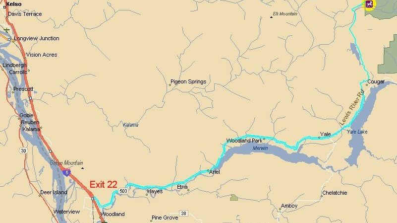
From the Kalama Horse Camp, which is on Road 81 about 10 miles north of Cougar, the trail
crosses the road, then soon picks up the track of an abandoned logging spur road. It must
have been quite a drive --- it's the steepest part of the trail.
From the camp at 2,200 feet of elevation, the old road climbs 1,000 feet in less than a
mile. It passes through an area that was planted in the early 1970s and now has trees 60
feet tall, with a few old-growth trunks mixed in.
The trail breaks out into the open a few hundred yards from Goat Mountain, which is the
highest point in Cowlitz County.
The trail carves up the hill through several switchbacks, then enters the Fossil Creek
drainage and contours across the western slope of Goat Mountain, through an old-growth
forest with some noble firs that are seven feet around.
For the next 1 1/2 miles or so, the trail stays close to level at around 3,600 feet.
Avalanche chutes offer views up 1,300 feet to the cap of Goat Mountain. Snow can fill the
chutes until June, making hiking dicey.
After a soft, mucky stretch, the trail reaches a saddle on the northwest flank of Goat
Mountain, then descends in a series of switchbacks to Coldspring Creek, which is crossed
at a ford. The abandoned 171 spur has been converted to trail, and leads to a portion of
Road 8123 that is closed because of a washout.
Though the volcano's peak is visible through trees in a few places, trails closer to St.
Helens offer much better views.
From the end of the Fossil Trail, riders can head east on Road 8123 for about a mile to
Trail Nos. 237 or 238 and make a big loop of 15 miles around Goat Mountain and back to the
horse camp.
Or they can ride up Road 8123 toward Sheep Canyon and more trail connections.
"New Cinnamon Trail "
The trail is 8.5 miles long and generally follows a ridge, with peaks as high as 3800 feet. It gains about 1400 feet in elevation, with most of the gain at the west end. It runs between the Kalama Horse Camp, on Forest Road 8100, and Redrock Pass. There are plenty of other trails in the area and the Toutle Trail #238 can be combined with it to create a 14 mile loop hike.