Manastash Ridge Green Dot Road Expansion
LT Murray Green Dot Road expansion includes Barber Springs & Hudson Mt on Manastash Ridge.
“Concerned Public Land Users”
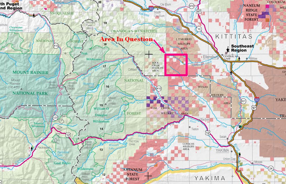
Area Map
Area in Question Map (please note, no Green Dotted roads in this area)
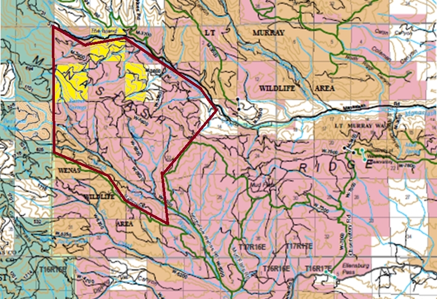
A little bit clearer Picture of the same area
Surprisingly, the area has apparently been part of a green-dot system since 2005. (according to DNR)
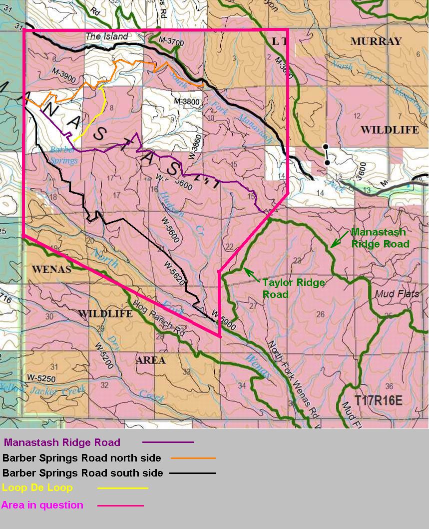
Based on the current LT Murray and Wenas Green Dot maps available on the DNR/WDFW websites, none of the various roads accessing Barber Springs ridge and Hudson Creek Hill have been designated a green-dot road. As such, nearly 7,000 acres of publicly-owned lands, much of it heavily used by hunters and other outdoor recreationists for well over 75 years, no longer has any [legal] public vehicular access. Even the Manastash Ridge Road is closed from Taylor Ridge west to Forest Boundary. (5.91 miles of it to be exact)
"Green Dot Road Expansion with no roads Green Dotted in the Expansion Area"
This means the normal access roads to National Forest Lands & Trails west off FR 1701 are closed to vehicles from the North & East Sides. The only access from Ellensburg is to go around to the Wenas and go up the Hog Ranch Road. The other access would be go up Bald Mt. Road from 410 & out FR #1701.
None of this area is posted as a Green Dot Road Management Area.
News
3/13/2013
Our group sent this email to
email: Barry Nilson - RMEF (Rocky Mtn Elk Foundation)
email: James Schroeder - TNC (The Nature Conservancy)
CC: Todd Welker - DNR (Department Natural Recourses)
Mr. Nilson and Mr. Schroeder,
Please see the attachment, that describes a conservation opportunity/need that is very closely linked to the Rock Creek/Bald Mountain "Heart of the Cascades" project your organizations spearheaded.
If you have any questions, or suggestions, please reply to this email, or call me.
Thanks for your consideration of this opportunity.
Please read in pdf format... Our attachment
Good Replies to our letter in pdf format... Reply 3-15-2013
2/21/2013
Mike Brathovde met face to face with DNR Regional Manager (SE Region) Todd Welker and DNR Alpine District Manager (Ken McNamee) in Ellensburg.
Watch for meeting highlights to be posted soon.
Mean while we are collecting support from other users.
DNR 2-21-13 Meeting Summary... Summary
2/9/2013
Mike met with officers from the Pacific North West 4-Wheel Drive Association at their 2013 Winter Convention.
According to Earl Nettnin, (Region 4 Director)
The PNW4WDA will support us in our endeavor to maintain wheeled access within the Green Dot System in this area.
![]() Pay attention to this... I had not heard this one...
Pay attention to this... I had not heard this one...
Found this on http://wdfw.wa.gov/lands/wildlife_areas/lt_murray/L.T.%20Murray/
IMPORTANT NOTICE
L.T. Murray is closed to all human entry (not just motorized vehicles) due to our winter elk feeding program.
The closure starts mid-December and runs until May 1st.
Does this mean I have been illegal when I snowshoe in there ???
![]()
Our Information Page about the Wenas Cooperative Road Management Area
Our Information Page about other Trail, Road & Land Closures
DNR Links...
http://www.dnr.wa.gov/recreationeducation/pages/home.aspx (Main DNR Recreation Web Site)
http://www.dnr.wa.gov/Publications/amp_rec_wenas_greendot_map.pdf (Wenas Cooperative Road Management Area Green Dot Road Map 2/2011)
http://www.dnr.wa.gov/Publications/amp_rec_ltmurray_greendot_map08_2010.pdf (LT Murray Cooperative Road Management Area Map 8/2010
Please note, the maps have not been updated recently
Back To Home Page Back To Motorized Off Road Vehicle Trail Reports & Closures